Colton
Map of 1855

Each map or group of maps is separated by a gray bar.
Malcolm Fowler's Map of pre-1748 grants in Bladen/Cumberland County, NC (opens in new tab)
Colton Map of 1855
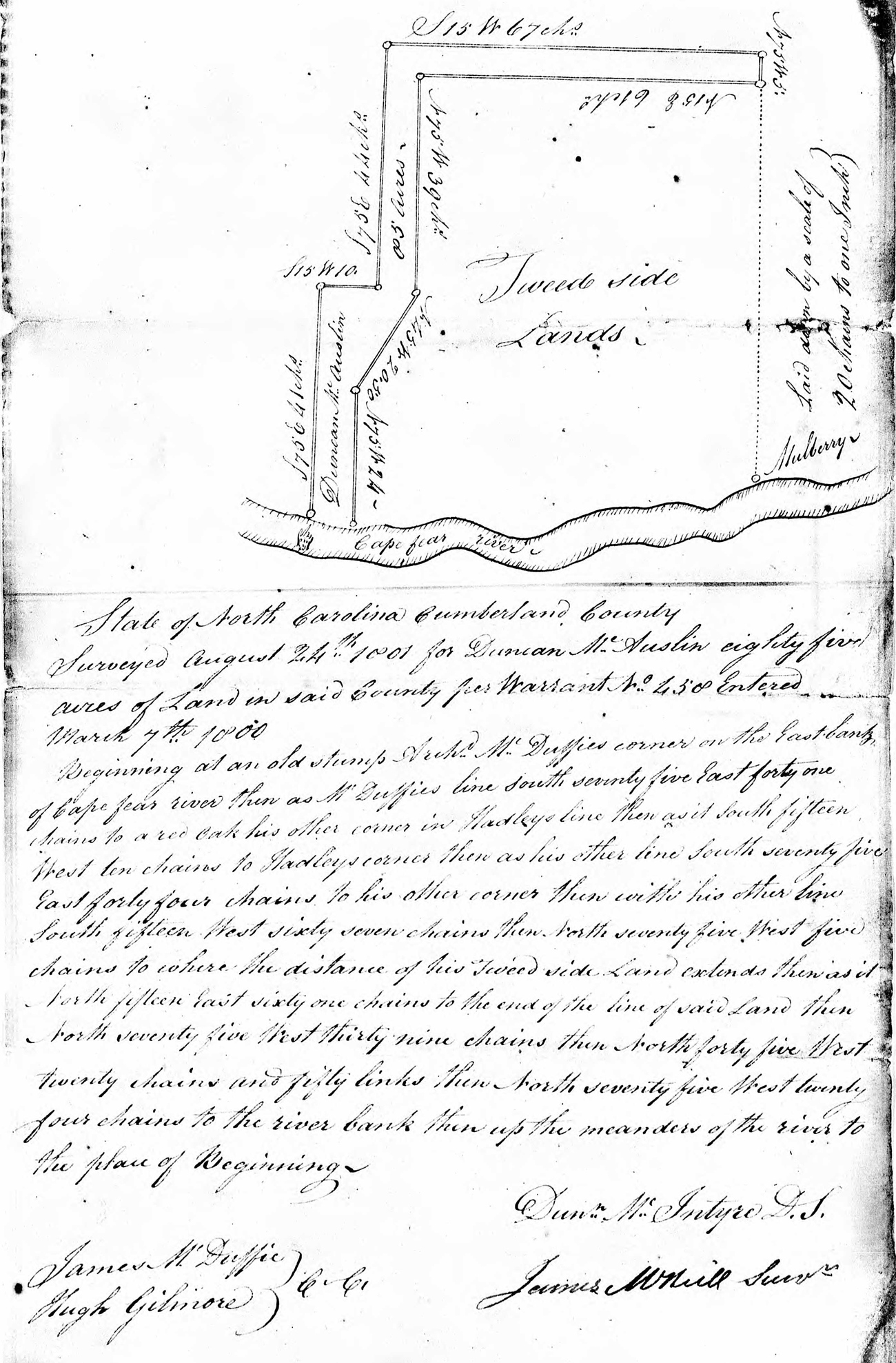
1801 Map of "Tweedside", the plantation of Daniel McNeill of Taynish
Location of Roger McNeill Meeting House on Cape Fear River
1834
Cumberland, Robeson and Richmond County lines
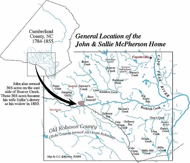
John McPherson, Jr.'s home and lands (grandson of
Old John McPherson of the Argyll Colony)
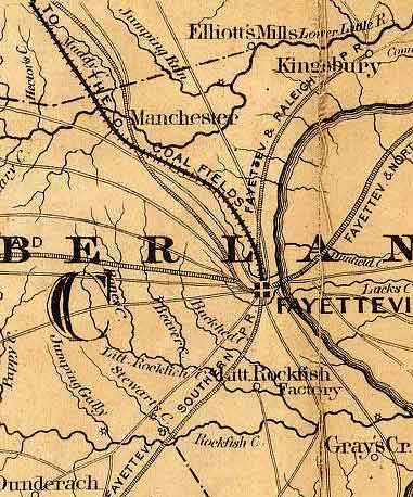
1863 Colton Map of of area around Fayetteville in Cumberland
County, NC
Area south and west of Red Springs, Great Desert,
and the Blackfork region of upper Robeson County, NC
The McNeill section of McCaskill's cemetery at Philippi
Church in Cumberland County, NC
Section of the 1884 McDuffie map of Cumberland
County, NC
Map of lands and location of the home of James McNeill of Rockfish Creek
Location of Job's Branch, the seat of Neill McNeill's
lands in Hoke County, NC
Greenbrier Lake and Jobes Branch
1840 Surveyor's plat of original lands of John McPherson
in Robeson County, NC
Topozone.com map of John McPherson's cabin on Raft
Swamp in upper Robeson County, NC
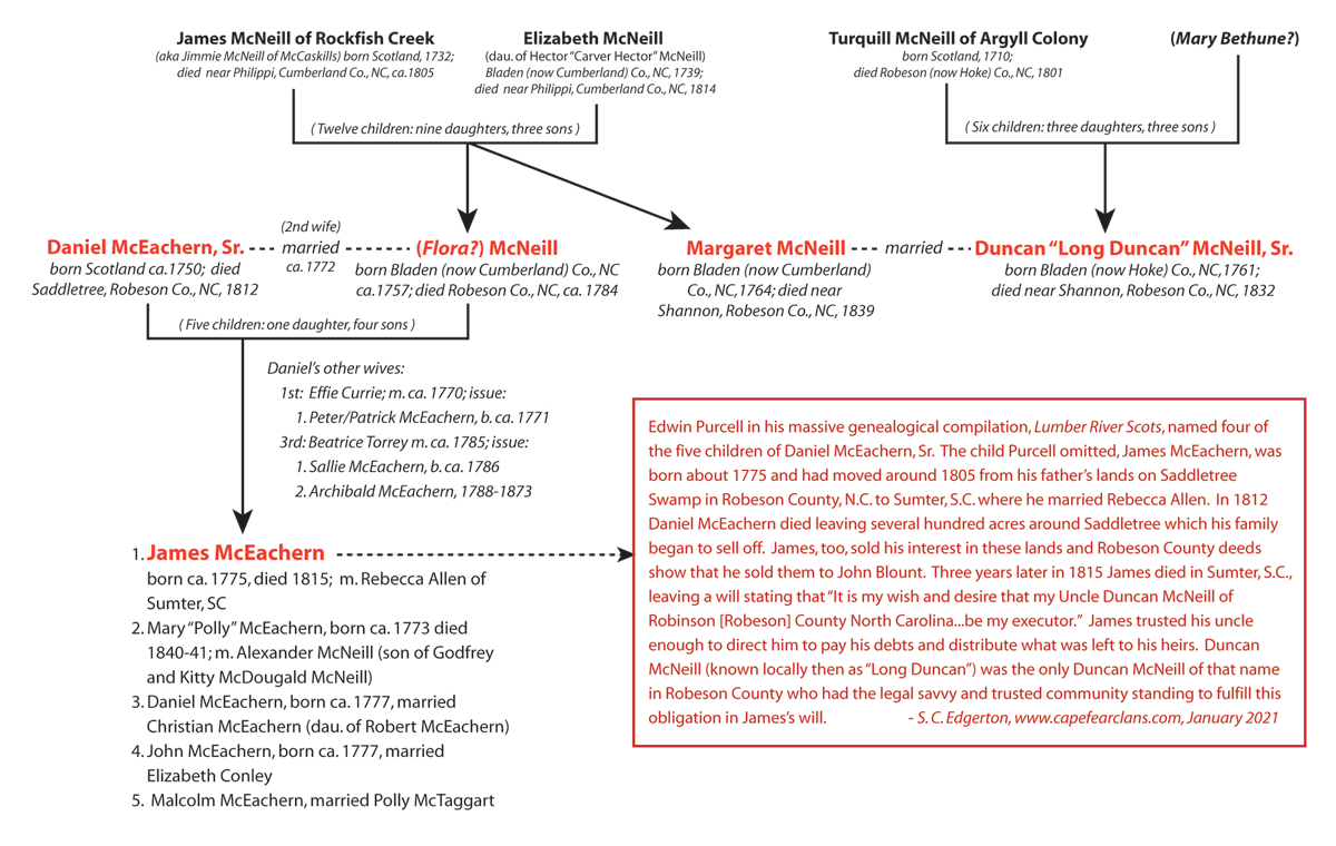
Genealogical Chart for James McEachern, son of Daniel McEachern, Sr. and his seconds wife, a McNeill
Bible Record of Barbara P. McNeill, ca. 1853
McLeod Map of the Alexander "Sawney" Graham Lands in Western Cumberland County
Colton
Map of 1855 |
|
"Tweedside", the plantation of "Squire McNeill", Daniel McNeill of Taynish
In 1743, Daniel McNeill of the Argyll Colony, called "Squire McNeill", bought from John Martinleer the tract which became "Tweedside". The course of the Cape Fear River was Tweedside's western boundary about 13 miles above the mouth of Rockfish Creek. When Daniel McNeill first bought it Tweedside lay in Bladen County, and today it's now in that part of Cumberland County that was taken away in 1754 from old Bladen to form Cumberland. |
 |
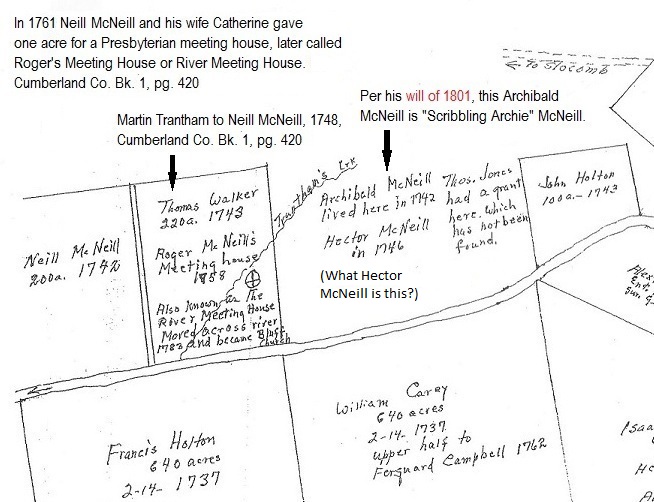
Location of Roger McNeill's Meeting House and "Little Neill" McNeill
The
map below (I've created links within it) is a small section of a larger map, one of many created by Dan McMillan, Fayetteville surveyor and architect, in his vast effort to lay out the lands of Scots immigrants and their immediate descendants along the upper Cape Fear. With input by Harnett County researcher Malcolm Fowler, this is McMillan's McKethan map and was created to show McKethan tracts around the Bluff area — also showing McAlesters and McNeills — including grants that pre-date the Argyll Colony of 1739. |
 |
| 1834 Cumberland, Robeson and Richmond County lines The northern corner of Robeson and the southwestern corner of Cumberland were taken from both counties to form Hoke County in 1911. I failed to find the source for this map, except the year the map was created. If anyone can identify this map, please contact me with that information. Thanks! |
 |
| Location of the home of John McPherson, Jr., the son of Alexander McPherson and Emily McGill. Alexander was the son of Old John McPherson of the Argyll Colony. John McPherson, Jr. married Sarah "Sallie" Black of Cumberland County. After John's death in 1829, Sallie migrated to Lauderdale County, MS in 1833. |
 |
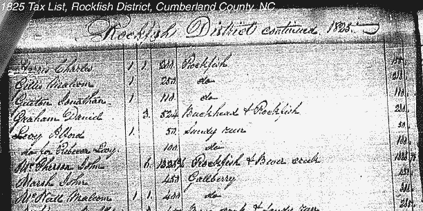
| 1825 Tax List for the Rockfish District John McPherson, Jr.'s 1829 Cumberland County tax entry, shown below, is shown because it has been believed that there were two John McPhersons who were neighbors at this time, and whose names were recorded adjacent to one another in the 1820 census. This double entry for John McPherson in the census (one on Rockfish and one on Beaver Creek a few miles away) only meant that he owned two separated tracts in the same district; indeed, the Beaver Creek tract appears to have had a household upon it. Indeed, the Beaver Creek tract became his widow Sallie's dower in 1830. When Sallie became pregnant out of wedlock in 1833, she moved to Lauderdale County, Mississippi, selling her dower to her son Edward. The total acreage of the two tracts was 1326 acres. The tax entry for 1829 and the years preceeding it clearly show there was only one John McPherson with 1326 acres of land. His 1829 estate record further proves this. |
 |
| 1863
Colton Map of of area around Fayetteville in Cumberland County, NC |
 |
| The
area south of Red Springs, including Philadelphus, Buie, the area just
west of the Great Desert, and the Blackfork region of upper Robeson
County, NC. Notice that Little Raft Swamp and McPhaul's Mill Swamp are the same watercourse. The Blackfork region, the wedge of land between Big and Little Raft Swamps, is in the top right quarter of the map. The broad delineations are township boundaries. Also, Richland Swamp, shown below running through Brown's Pond at Philadelphus, was known in early records as Soloman's Swamp and later as Scolding Branch. |
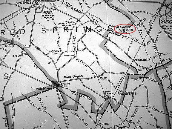 |
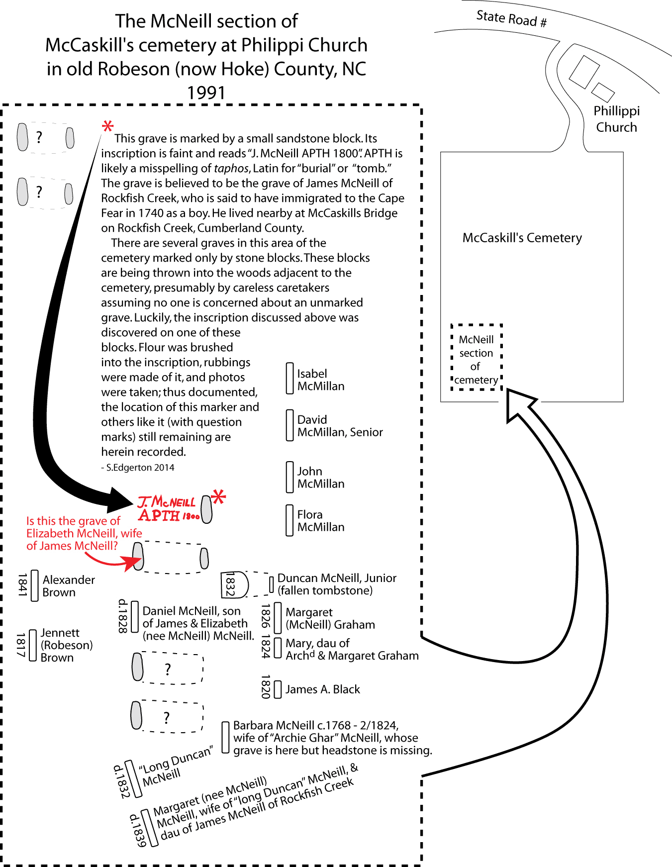
| The McNeill section of McCaskill's cemetery at Philippi Church in Cumberland County, NC. This cemetery is within two miles or so west of Raeford, NC, at Philippi Presbyterian Church. It is possibly where Turquill McNeill of the Argyll Colony is buried, as well as James McNeill of Rockfish Creek (aka 'Jimmie McNeill of McCaskills Creek'.), and other local Scots of their time. Click the image of the little grave with the sandstone marker to see the inscription. The inscription had flour rubbed into it to make it more readable. It says "J. McNeill APTH 1800." APTH may be a misspelling of a latin or greek word meaning "tomb" or "burial." This is likely the grave of James McNeill of Rockfish Creek. My mother wrote before her death that her grandfather, J.F. "Frank" McKay (1849-1941), told her that James McNeill came to America in 1740; he would have been eight years old at the time. His parents are unknown and anyone who claims they know are guessing. The grave of Duncan McNeill, Sr. is that of "Long Duncan" McNeill; Long Duncan's wife Margaret (daughter of James McNeill of Rockfish Creek) is buried beside him. Long Duncan McNeill was the son of Turquill McNeill of the Argyll Colony. Archibald "Archie Ghar" McNeill was buried in this cemetery next to his wife, Barbara Patterson McNeill (close to "Long Duncan" McNeill's grave) but, today, Archie's tombstone is missing. |
 |
|
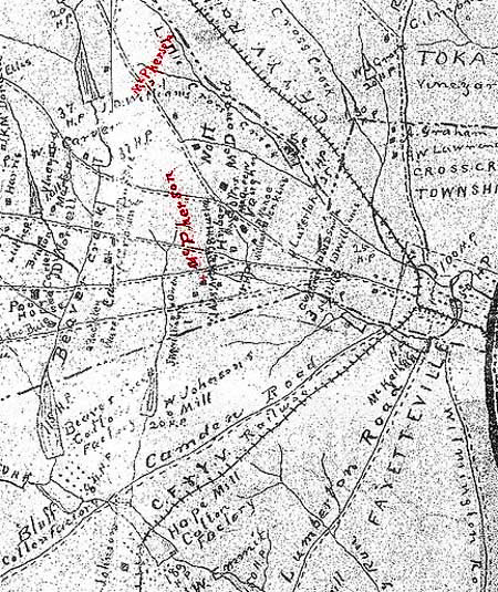
A section of the 1884 McDuffie map of Cumberland County, NC, showing the general location of two McPherson families' landholdings (written over in red) west of Fayetteville and the Cape Fear River. One is just left of center, and the other is right above it near the top. The McPherson lands at the top combine the Malcolm McPherson and Alexander McPherson of Jura lands. The McPherson lands toward the bottom are the lands of Old John McPherson who entered tracts to be surveyed in 1753; the small cross beneath that area is the site of McPherson Presbyterian Church, the lands of which were donated in 1802 by Colin McPherson, the grandson of Old John McPherson of the Argyll Colony. |
 |
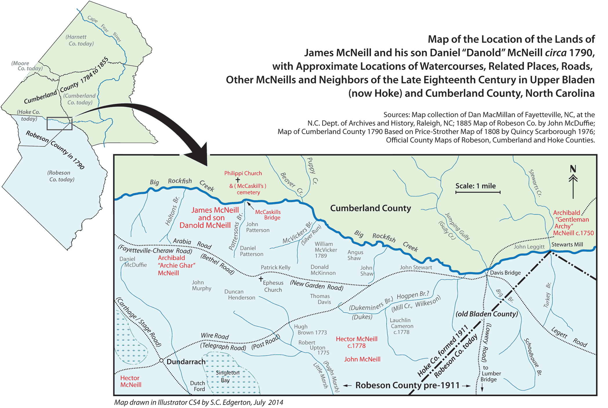
A
map of the lands and homesite area of James McNeill of Rockfish Creek (aka Jimmie McNeill of McCaskills) is known to have lived inside Cumberland County near McCaskills Bridge on Big Rockfish Creek near Philippi Church and cemetery. Most all of his lands were in Robeson County on the opposite side of Big Rockfish. Philippi cemetery, originally called McCaskills cemetery, was an early burial place for Scottish settlers. The map has links within it to information about some of the McNeills shown. The men shown come from the research of Dan MacMillan of Fayetteville who placed them on one of his maps that I used for my research on James McNeill and some of his neighbors. I'm particularly interested in the Hector McNeill near Lauchlin Cameron just south of Dukeminers Branch. I believe this Hector wrote his will in 1778 naming his wife Margaret and leaving slaves to the Bluff McNeills and a John Johnston. He mentions Lauc Cameron and his mother Isabella Buie. Notice the "Bluff Archie" McNeill's land is to the far right on this map.. |
 |
|
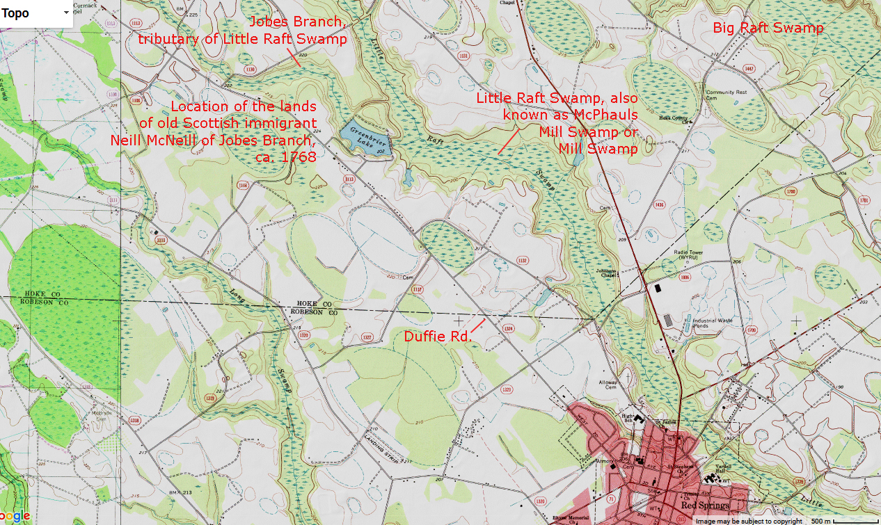
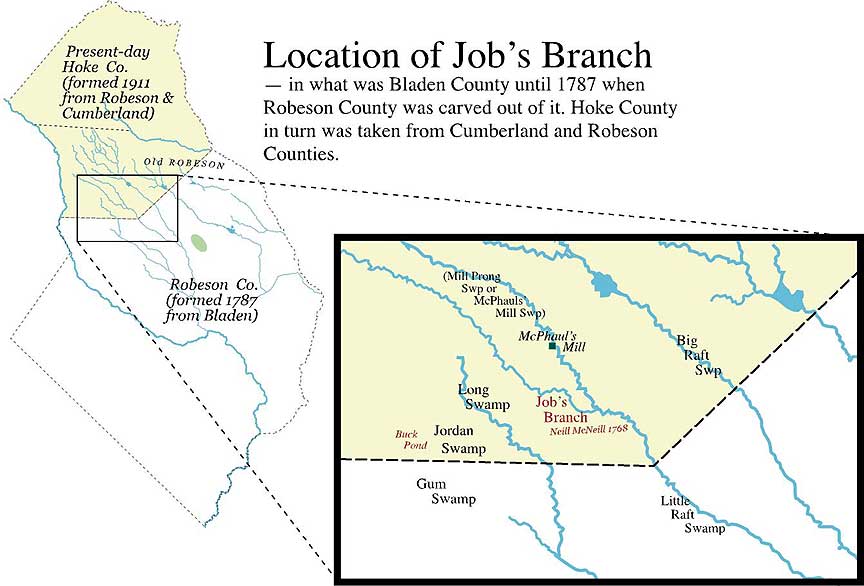
Greenbrier Lake on Jobes Branch, the seat of Neill McNeill's lands in Hoke County, NC. This is likely the location of "Neill McNeill's burial ground" mentioned by Col. Neil Buie in his 1828 deposition which provided details about the time and burial place of Daniel and Marian McNeill McPherson's young son Archibald who died in 1790. According to James M. Roberts in his history of the descendants of "Sailor Hector" McNeill, Sailor Hector's father Neill McNeill was buried "in front of 'Big Will' McNeill's house on Duffie Road, Robeson County, N.C." This "Big Will" McNeill (there were two men with that nickname in Robeson County) was the son of William Peterson McNeill and wife Catherine (née Shaw) McNeill. A map given to me by Ruth McArthur (given to her by her cousin Charles McNeill who still lives in Red Springs circa 2005) shows Big Will's house was at the entrance to Greenbrier Lake on Duffie Road. These lands were bought initially in 1768 by Neill of Jobes Branch and inherited by his two sons, "Sailor Hector" and "Shoemaker John" McNeill. Neighbors to the McNeills around Jobes Branch were Archibald Brown and the family of Malcolm Brown and his sons, including Neill B. Brown, Sr., who married Mary McNeill, a great-granddaughter of Neill McNeill of Jobes Branch. |
 |
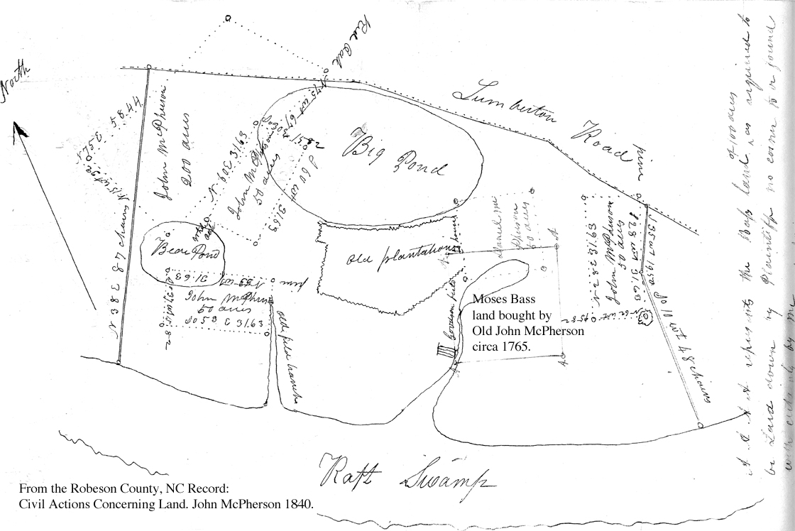
| The surveyor's plat below is found in a folder called "John McPherson, 1840" under "Civil Actions Concerning Land" in the Robeson County records at the NC Dept. of Archives and History. I recommend such records to any researcher for all the genealogical and property information that can determine land location, vanished landmark names, time of purchase and purchasee, and possibly distribution by heirs of the original owner(s). This map shows in detail the disjointed grants and tracts bought by Old John McPherson and his son Daniel dating from the 1760s up to around the time of Old John's death in 1791. The land between the various plats was by 1820 entirely owned by the McPherson family, and the whole as shown below is half of the McPherson family estate disputed from about 1823 until 1845 by Old John's granddaughter Catherine McPherson Brown and her brother-in-law Gilbert Gilchrist. The other half—some 1100 acres owned by Hugh and Colin McPherson from 1796 until the year 1823 when they were both deceased—adjoins the lands shown below on their left edge and likewise lay between the Lumberton Road and Raft Swamp, and continued beyond the location of the bridge at Juniper Branch and the Raft Swamp further on. There appears to have been a Juniper Branch on both sides of the Raft Swamp and they drained into the swamp at the same place, but I may be wrong about this. The "old plantation", centrally located in the middle of the map, is probably the first tract purchased by Old John McPherson upon settling in Bladen County in the mid-1760s, and which he probably acquired at the same time he bought the Moses Bass tract (Moses Bass, found in the 1755 Cumberland County tax list, owned a mill in this region and lived on this tract in 1758). McPherson's log home was located in this irregular-shaped tract on its far right side, marked by a tiny box. The Big Pond and the Bear Pond are now gone, certainly drained and cleared by subsequent owners, but which can be seen on the topozone map (see next map below) if it is compared with the hand drawn map shown just below this text. With regard to the two maps below, it should be noted that Juniper Branch, now located as a branch draining into the Raft Swamp from its south side, was originally the small branch draining into the Raft Swamp from its north side (see topozone map below). I have come to suspect that at the time the McPhersons owned this land, Juniper Branch drained into the Raft Swamp from the north and south side of the swamp because the topo map below shows that a branch did at one time drain into the swamp on the north side of the swamp directly across from today's Juniper Branch on the south side. This entire estate was located just above the current intersection called McLeod's Crossing in northern Robeson County, just east of Red Springs. McLeod's Crossing was originally called "Godfrey's Crossing" as it was the crossing of the Old Lowery Road and Lumberton-Carthage Road where Godfrey McNeill's house stood. After that it was called "Weaver Neill McLean's Crossing". It has been said the house standing there today on a rise near the intersection's northeast corner was indeed Godfrey McNeill's house, but this is yet to be proven. In the late 1700s, other neighbors in this area included the families: Council, Peter Dallas, Henderson, "Big John" Johnston and his son Daniel Johnston, Esq., Alexander McArthur, Peter and wife Peggy Campbell McArthur (2nd McArthur link), John McBryde, Daniel McIntaggart, Godfrey McNeill and Malcolm Munroe and Peter Munroe. |
 |
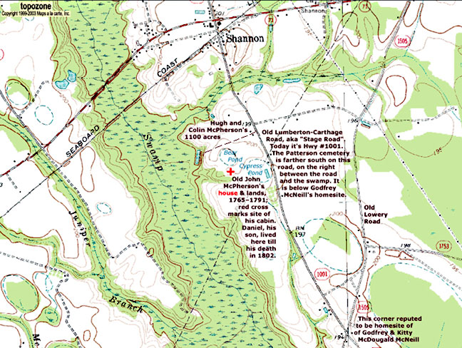
| Topozone.com is a very good site with which you can match current topography with surveyor's plats. Compare the map below with the plat of Old John's land just above. The town of Shannon is almost due north of the red cross, which is the site of Old John McPherson's cabin. I took the topozone map into Photoshop and added the text and labels pertaining to the McPhersons and their property. At the bottom of the map is the reputed homesite of Godfrey McNeill, at what was called Godfrey's Crossing and is now referred to as McLeod's Crossing. This crossing is the intersection of the old Lowry Road (Hwy 1505) and the Carthage to Lumberton Stage Coach Road (Hwy 1001). |
 |
Genealogy of James McEachern and his Mother, a McNeill
The When Edwin Purcell wrote Lumber River Scots in 1940 he was not aware of James McEachern being a son of Daniel McEachern and his second wife, a McNeill. My research into most all of the McNeill families of Robeson and Cumberland counties in NC has revealed that, while her first name is lost, her parentage has been identified. In James's will of 1815 in Sumter County,SC he named "my uncle Duncan McNeill of Robinson County" his executor. The only Duncan McNeill of 1815 in Robeson County was the one and only "Long Duncan" McNeill, man of standing the community who also had the legal savvy to manage the executorship. The chart below shows not only how "Long Duncan" was James's uncle but who James McEachern's namesake was. Note James McNeill's family ties to the children of Daniel McEachern. Many of the names below are clickable links. |
|
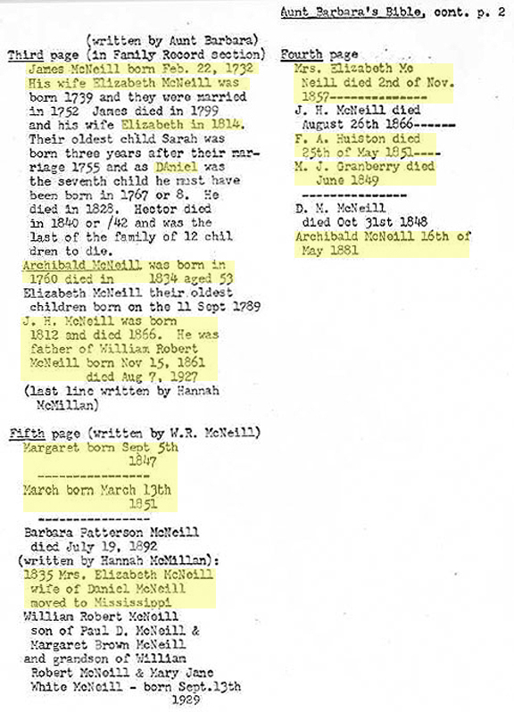
Barbara P. McNeill's Bible Record
This bible was printed in 1853 I believe, but it belonged to Barbara Patterson McNeill, the unmarried daughter of Daniel "Danold" McNeill and his wife Elizabeth (née McNeill) McNeill, and now belongs to their descendants, the heirs of Mrs. Mary Lou Stack Huske of Charlotte. "Aunt Barbara" and she is supposed to have written down the information below, probably from memory. I hope one day to have a high-resolution photo of the original information that is the source of the typed page below. The typed version is a page from Mabel Smith Lovin's McNeill histories. I don't believe Mabel knew the identity of the James McNeill who is stated below to have been born in 1732; he was James McNeill of Rockfish Creek so often mentioned on this site, and the father of Danold named above. Run your cursor over the names below to find clickable links to more information. |
|
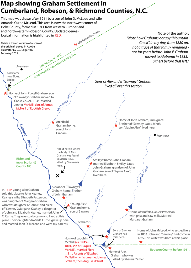
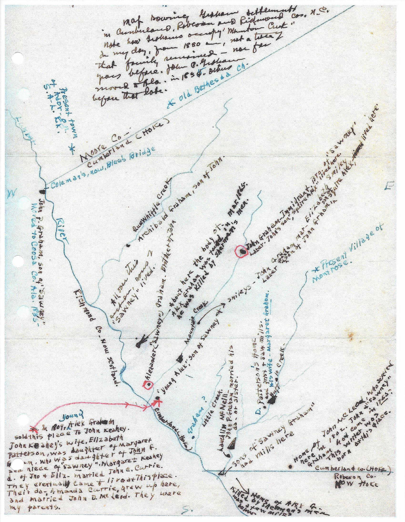
Map of the Lands of Immigrants John Graham and his brother Alexander "Sawney" Graham, after 1911
This hand drawn map was sent to me a few years ago. The original was drawn by a McLeod man, name unknown, a son of John D. McLeod and wife Amanda Currie McLeod. My research into deeds and other official records require updates to some of the information that was on the original map. There are a number of links, so hover over each entry or name below. "Buffalo Daniel" Paterson's home is identified below as well. I'll be adding more links in future. |
|